
KĀRIZ, underground irrigation canals also called qanāt. Middle Persian form kārēz (< kār- “to draw furrows” and rēz- “to flow”) will be used in this article. In official Iranian administrative parlance, the Arabic term qanāt has become the preferred technical term.
Karez are common throughout the Middle East, and they can be found all the way from the Gobi Desert to Spain. They have different names in different cultures: in Berber Arabic, they’re called foggara; in Persian, qarez; in Spanish, acequia, and in Turkish, qanat.

Above is an image created by Sue Hutton showing a cross-section of a qanat in Oman. Structures of this type collect water in the rock, sand, and gravel aquifers at the edges of the mountainous region in northern Oman. They run underground for kilometers and emerge at oases. In Oman they are also known as dawoodi or iddi falaj.
Besides its use in irrigation, a qanat can also be used together with a windcatcher to cool a building without using any electrical power.
Many qanat in Iraq were destroyed during the American invasion.
https://www.azimuthproject.org/azimuth/show/Qanat
In Iran, North Africa, and Spain, subterranean canals equipped with a series of ventilating shafts leading to the surface were built to extend 20 kilometers (12 mi) or more. Like more basic devices, they had existed for centuries before Islamic civilization adopted and refined them: According to historian Charles Singer, they were carried from Armenia to Persia around the sixth-century bc, and from there spread west to Egypt and across North Africa to Morocco. Malpica observed that the Arabs preferred to irrigate by canals from underground springs because—unlike rivers, which often dried up in the summer—the water was available year-round.
Islamic engineers used astrolabes, spherical and plane trigonometry, and complex surveying techniques to layout the canals and to site dams, many of which were built so solidly they have endured into modern times.


Continuing east to central Iran, a series of brick domes and wind towers poke distinctively above the skyline of the city of Yazd, indicating the presence of subterranean reservoirs called ab anbars. Relatively late constructions of the Safavid and Qajar eras in the 18th century, these buried pools, some 10 meters (32') below surface level, keep water cool by means of vented towers that circulate in fresh air from the outside, both by capturing breezes and by natural convection over the cool water surface. Some of the grander ab anbars include public baths, shops, and coffeehouses. Although there are between 75 and 90 surviving ab anbars in the Yazd region, most are in a precarious state, and a number are on the verge of collapse.
South across the Strait of Hormuz, Oman’s aflaj (singular: falaj) are man-made networks of canals, both underground and on the surface, similar to qanats and their kin. The aflaj has watered the riverless country for more than 2700 years. Today, they still deliver more than 70 percent of the nation’s total water needs.
In contrast to these North African and Middle Eastern waterworks that have on occasion remained in use, in Spain many of the Andalusian waterworks were forsaken when the Arabs left, according to Thomas Glick, a historian of technology at Boston University. As Christians switched from widely varied Arab crops to the planting predominantly of vineyards and cereals, they required less water for irrigation, he explains.
PHOTOS12.COM / ORONOZ / TOPKAPI LIBRARY
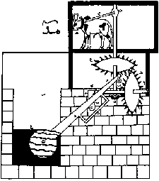
With this design, here sketched schematically after an original in the collection of the Topkapı Library in Istanbul, historians Donald Hill and Ahmad Hassan credit al-Jazari with the first known use of a mechanical crank. Animal power turns the large meshed gears, and the horizontal axle turns a crank whose rotation alternately pushes up a channeled, flume-beam swape and allows it to fall. In its lower position, the swape’s scoop submerges to be filled; the shift in the crank’s position raises the swape up out of the water and tilts it so the water runs down the flume-beam and pours into a cistern or irrigation canal. The sketch exaggerates the angle through which the swape is raised.
https://archive.aramcoworld.com/issue/200603/the.art.and.science.of.water.htm


The kārēz conducts water from the level of an aquifer to the open air by means of simple gravity in order to distribute it to lower areas. This technology is primarily used for irrigation (ābyāri) and allows for the cultivation of approximately 1,500,000 hectares worldwide, or about 0.6 percent of the total irrigated surface area (Balland, 1992a, p. 1). Underground water channels originated in the highlands of Iran and Afghanistan, where until today they have remained the preferred irrigation technology.
The Karez systems of Turpan (Xinjiang province, NW China) are one of the most extensive agglomerations of ancient subterranean tunnel-wells in the world (English 1968), and demonstrate an impressive version of ancient water harvesting technology. In Iran, these systems are known as Qanat (which is an Arabic term, English 1968) or Kariz (which is a Persian term), and in northern Africa as Fuqara. Similar systems are known from Mexico from Spanish times (Galerias; Kortum 2004). All in all, such systems are known from more than 34 countries in the world (see Fattahi 2015 and references therein).
Located typically in arid environments, with annual rainfall between 100–300 mm (Lightfoot 1997), this sustainable technology gives access to buried water resources by conveying groundwater by gravity to the surface, feeding large oases during the past and documenting the technological potential of our ancestors ~2500–3000 yrs. BP, when the first Qanat systems have been invented probably in the surroundings of Tehran or somewhere in Persia (Kobori 1973; Lightfoot 1997). Some ancient capitals were based on Qanat irrigation, e.g. Palmyra (Kobori 1973).
However, the exact dating of the origin of these systems is difficult. Fattahi et al. (2011) dated Miam Qanat in NE Iran by Optical Stimulated Luminescence (OSL), but due to a minimal number of samples, the age estimation remains doubtful. If the first dating is correct, the oldest known Karez dates further back to 3600–4300 yrs. BP. Also, Bailiff et al. (2015) did OSL on Qanat systems in Aragon, Spain, constructed in the 15th century.
Chinese scholars assume that the technology was developed independently in mainland China and was brought to Turpan during the first period of Chinese control over the area during the Han dynasty (220 BC–206 AD), which is why Karez rank among the three “Great Ancient Chinese Works”. However, neither the term Karez or the Chinese Kan er jing nor a description of specific gravity-fed underground channels can be found before the Qing dynasty. According to a critical study and interpretation of Chinese historical sources, Trombert (2008) dates the Karez of Turpan to the early 19th century. This is close to Huntington (1907), who assumed a Persian origin and dated the invention to Turpan to ~1780 AD. In Chinese history, the Karez is referred to as “The underground great wall” as part of the three great construction projects in ancient China (along with the Great Wall and the Beijing-Hangzhou Grand Canal; Abudu et al. 2011).
Materials and Methods
Karez systems were constructed by digging short vertical shafts into the loose fanglomerates or alluvial fans in the foreland of dryland mountains. In general, these piedmont surfaces are distinctly inclined. At first, the constructors explore for groundwater proximal to the mountains by digging a so-called “mother well”. After success, the Karez shafts are dug, beginning at the final (English 1968). Proceeding upslope, further shafts are built and connected by a gently sloped underground channel, draining the water to the outlet in the oasis (“telemai”, which is an Uyghur term, Lein & Shen 2006). The length of the Karez in the Turpan basin varies from three to 50 km (Sun et al. 2009). The distance between the shafts is about 20-30 m close to the outlet and increases to 30–70 m to the mother well in the oasis. There, some shafts are more than 100 m deep (Lein & Shen 2006). It takes up to eight years to build a Karez system (Sun et al. 2008). In comparison, the Qanats in Iran have mean lengths of about 4.2 km (Kortum 2004), with a maximum of 120 km (Zarach Qanat, Molle, et al. 2004), and vertical shafts of up to 150 m deep (English 1968). Most likely, the shortest Karez systems, and the shafts close to the basin, are also the oldest ones. In Turpan, modern Karez had to be dug deeper and the Karez tunnels become longer due to the drawdown of groundwater, which started in the 1950s, subsequent to the expansion of cultivated land by 30% during one decade (Lein & Shen 2006).

TECHNOLOGY
(1) Grade. The technology of kārēz exploits a difference in grade between a tunnel and the groundwater table. The grade of the tunnel is less steep than the grade of the water table,


so that the tunnel ends at an elevation distinctly higher than that of the water table. Each tunnel consists of two sections: a supply or drainage section upstream penetrates the water table in order to capture the water, and an adduction section downstream is located above the level of the water table in order to transport the water to the land to be irrigated. In Iran, the average grade maybe around 0.5 percent (Goblot, 1979, p. 27), but between 1 and 2 percent in Oman (Weisgerber, p. 71). These gradients allow the water to flow while avoiding an erosion of the tunnel by too rapid a rate of flow.2
2. https://iranicaonline.org/articles/kariz-parent
Length. In a few exceptional cases, the channels are quite long. The known maximum lengths are some 50 km in the region of Yazd (Beaumont, 1989, p. 23) and about 35 kilometers at Gonābād in Khorasan (Goblot, 1979, pp. 35-36).
Vertical shafts. The channel is the essential functional element of the kārēz, but vertical shafts, which connect the tunnel to the surface, are needed for digging the tunnels and play no role in the actual operation of the kārēz. The vertical shafts are laid out at more or less regular intervals, which are relatively close in order to facilitate the removal of debris. In Iran, the average interval might be on the order of 20 to 30 m. Good planners, in order to assure the profitability of their work, try not to increase their number too much and dig the shafts with the greatest possible distance between them, at times from 50 to 100 m (Goblot, 1979, p. 36). The alignment of the chains of shafts, whose circular openings are marked by small mounds of debris and which are clearly visible, in particular to aerial observers, are one of the most spectacular and characteristic features of the Iranian landscape.


Construction. The work on a kārēz (Goblot, 1979, pp. 30-36) begins with a survey of the probable existence of a water table uphill on the slope. There are various indicators of a water table, which are usually found near its natural outlet. An exploratory shaft (gamāna; cf. gamānidan “to think, to believe”) is sunk down to the level where one hopes to reach the water. When the shaft hits the water table, the gamāna is used as the uphill head of the channel and will be called the mother well (māder čāh). The water immediately begins to seep through the base and sides of the shaft, but the worker has time to rapidly dig several meters of the water-bearing channel before the bottom of the shaft is flooded, since generally, the seepage is slow. When the soil has become too moist to continue working underground, the worker returns to the surface. Several days are required for the stabilization of the water level, and it is impossible to continue the work from the mother well since the channel would be completely flooded. The excavation of the channel is therefore paused for several days after the digging of the mother well, and it must always be continued from the proposed location of the outlet downstream. The determination of the outlet is an essential element of the construction process. Its location follows from that of the areas to be irrigated, but the outlet must also be situated on a contour line compatible with the normal flow of the water at its elevation at the bottom of the mother well. Precise surveying is thus necessary.
In the 19th and 20th centuries, modern surveying methods relied on a spirit level equipped with a telescope, and on a surveyor’s rod carried by an aide. The traditional empirical methods were more or less complex. As they had been practiced for a very long time, they were occasionally still employed in the 20th century. In the 1950s Anthony Smith (1957, pp. 92-93) observed a traditional surveying method in the region of Kerman. The process begins with gauging the depth of the mother well with a plumb line. Afterwards a second line is attached to the rim of the mother well, while the other end of it is tied to a stake held by an aide, who moves away in the approximate direction of the channel. When the line is almost taut, the stake is fixed in the ground. The taut line is then wetted, and if the drops of water flow neither in one direction nor the other, the line is considered to be horizontal. The third step is to mark the distance between the ground and the point at which the line is attached to the stake with a knot on the plumb line of the mother well, starting from the top. These three steps are repeated until the end of the plumb line is reached. The last point on the slope downstream where the stake has been fixed in the ground is then at the same elevation as the bottom of the mother well, as well as approximately at the same level as the water table.
A slightly more refined method, involving the aid of a mechanical device, was described by M. A. Butler in the early 1930s, although Henri Goblot (1979, p. 33) stressed that he himself had never seen this device. It was known from experience, independent of any mathematical demonstration, that the four corners of a square are right angles; that is, the four sides are perpendicular to each other. A square is constructed from four wooden laths of the same length, and rings are fixed at the four corners. A plumb line is attached to one of the corners to determine the vertical and to mark the horizontal a rather long rod is passed through the two rings, left and right of the corner with the plumb line. The device is then positioned above the opening of the shaft with the help of a small derrick so that one can take a sighting on a surveyor’s rod held by an aide


This operation is repeated until the sum of the resulting measures of successive sightings is equal to the depth of the shaft. In order to avoid the addition of sums, the results of the sightings are transferred to the plumb line, measuring the depth of the shaft with the aid of knots, as in the preceding method.
Once the survey has established the starting point for the channel’s excavation, its course is laid out on the surface of the ground up to the mother well. The open-air channel becomes a tunnel as soon as it diverges from the surface by 2 meters. It is essential that the tunnel follows a straight line, on the course laid out above ground. The worker traditionally uses an oil lamp, which is hung from the ceiling to ensure that he is digging straight. In the working area, the lamp casts a shadow, which must remain continually in the center of the leading face of the tunnel. To further facilitate the worker’s staying on the tunnel’s set course, two plumb lines are hung into each excavation shaft, to the end of which a rod is attached. The direction of the rod parallels the course of the tunnel as marked above ground. The gradient is obtained by a suspended square, with a line attached to the top; one mark at the horizontal and two marks on each side indicate the maximum slope allowable. As the worker progresses upstream, he digs a furrow, which will serve to drain the water along the tunnel’s base. In order to avoid loss by percolation, the furrow can be lined with a mortar (šefta) containing lime. All this work is carried out with classical miner’s instruments, such as a pickaxe and a winch for hauling out the debris.
When the channel has been completed, the workers seek to increase its output, if possible. One method is to enlarge the surface area where the seepage occurs in the part of the channel supplying the water, either by extending it upstream beyond the mother well or by digging side-tunnels, which join the main channel in a fishbone pattern or converge on a single shaft in the shape of a star (Goblot, 1979, pp. 34-35). Another method is to construct a second channel below the first one, so that water lost through infiltration from the upper channel can be reclaimed. The kārēz in Gonābād cited previously, and of Mon, near Ardestān seems to have been planned in this way from the start (cf. Safi-Nežād, 1992, pp. 64-65). In the majority of cases, however, it is most probable that the lower channel was constructed later when depletion of the water table had rendered the upper channel unproductive.
The tunnels require very careful maintenance, which includes more or less frequent repair of collapsed walls and ceiling and cleaning of the pores through which water from the water table percolates, whenever they are blocked by sediment. When the walls are highly degraded, they are reinforced by rings of baked clay (kaval), on average 1.2 m high, 0.5 m wide, and 0.2 m thick, which can fit into each other to create a continuous surface (Goblot, 1979, p. 35 and pls. 8 and 10 after p. 48).3
3 Xavier de Planhol, “KĀRIZ ii. TECHNOLOGY,” Encyclopædia Iranica, XV/6, pp. 565-569, available online at http://www.iranicaonline.org/articles/kariz_2 (accessed on 30 December 2012).
Water supply. The absolute discharge is measured in cubic meter per hour (m³/hr) and varies from kārēz to kārēz, as it depends on the local conditions of supply to the water table and a channel’s length. In a study of 2,000 channels in Iran, Beaumont (1989, p. 23) has calculated that the discharge is always lower than 300 m³/hr. While two-thirds of the channels discharge less than 60 m³/hr, for 45 percent of the channels the discharge is less than 30 m³/hr (Beaumont, 1971, p. 47). The latter water flow allows for irrigating 10-20 hectares of land. For Iran, an average discharge of 54 m³/hr has been calculated, and the highest known discharge is given by a kārēz at Šāhrud, which yields around 3,200 m³/hr (Goblot, 1979, p. 41). In addition to its absolute discharge, the productivity of a channel must be assessed in its relation to the region’s water resources. A channel’s specific discharge measures the liters of water per second per kilometer (l/sec/km; cf. Balland, 1992b, p. 106). In Iran, the specific discharge is about 3 l/sec/km, but about 8 l/sec/km is its average in Afghanistan. The particular efficacy of the Afghan kārēz seems to reflect that the Afghan channels are generally shorter (see ii (2), above), while the area supplying the water is larger. In all other regions, from Turfan to the Sahara, the specific discharge remains in the lower range of 2-3 l/sec/km (Balland, 1992b, p. 107, fig. 4).
The major significance of the kārēz lies in its continuous discharge throughout the year. In contrast, irrigation systems that rely on surface water runoff can completely cease to discharge water during the dry season. Continuous discharge, however, needs to be distinguished from a constant discharge. Significant seasonal variations can be observed in the discharge of the subterranean aquifers, although these variations are much smaller than those of the rivers. In a study of 24 kārēz in the region of Mashad in 1964-65, the maximum discharge occurred from February to May, and the lowest discharge was measured in September and October. The same phenomenon has been noted in Afghanistan. A study of 7 kārēz in the region of Kabul calculated an average of a 29-percent decrease for the discharge between July and September 1963 (Wagner, p. 108). These variations basically mirror the regular pattern of temperatures, although with a slight time lag, as the heat increases evaporation and thus decreases the supply of water to the water tables. But variations in precipitation and local conditions of available runoff water are also important since they can cause significant differences from one year to another (Beaumont, 1971; Balland, 1992a, p. 103). In general, the seasonal variability reflects the permeability of the surrounding rock and the thickness of the aquifer. The kārēz that drains a shallow, local water table of small volume covered by a very permeable detrital material shows the greater seasonal variability, and it may even temporarily ceases its discharge. For Afghanistan, S. Radojivic described both the occasional drying up, as in the case of the kārēz of Ḡolām Ḵān at Sehgāna in Katawāz (1978a, p. 51), and the recurrent drying up for 4-6 months every year, which has been observed for the kārēz at Pol-e Sangi, about 11 km northeast of Kabul (1978b, p. 2). Farmers are of course aware of these variations since a constant discharge increases the value of the arable land (Taraki, p. 622). Consequently, they distinguish between a kārēz with constant discharge (Pers. ḡarq-āb, āb-ḡari, cf. McLachlan, p.77; Pashto kārēz pāḵə in Afghanistan, cf. Balland, 1992a, p. 103, n. 5) and one whose discharge is fluctuating according to rainfall (Pers. hāvā-bin, pošt-āb in Iran; Pashto kārēz wahri in Afghanistan, cf. Balland, 1992a, p. 103, n. 6). In southern Afghanistan N. E. McClymonds studied the impact of the extreme drought of 1970 and 1971 (Balland, 1992a, p. 105). In the region of Kajakay, the average discharge of 73 kārēz fell 60 percent in comparison with their discharge in 1950, the year for which measurements were available. Because of improvement or repair works, 9 kārēz had nevertheless experienced a modest increase of their discharge, 6 percent on average, while in 3 kārēz the discharge remained unchanged. But in the other 61 kārēz the discharge dropped on average 72 percent, and 4 channels had even dried up completely so that the dependent villages had been deserted. The number of kārēz supplying more than 50 l/sec had fallen from 15 to 1. Since the closest meteorological stations of Laškargāh and Kandahar measured in 1971 a rainfall deficit of 47 and 70 percent, respectively, overexploitation of the water tables could be ruled out, and this fall had to be attributed to the disastrous rainfall situation in 1970 and 1971.
Lastly, many kārēz are destined to dry up eventually because their water tables are overexploited. Such long-term variations are irreversible without radical modification in human attitudes. For example, an ill-considered multiplication of channels will deplete the water table, which in turn causes the water level to drop permanently.
(2) Geographical characteristics. Preferred sites for the construction of kārēz are those that have sufficiently and regularly supplied water tables and are located below abundantly watered mountainous terrain, where the channels can emerge into plains with good cultivable soil. Piedmont areas thus seem to be the best, especially since the nature of the surface materials (regolith) is generally quite favorable for water infiltration. Within these areas, the alluvial cones are especially favorable, watered as they are not only by a runoff on the main slopes but also by drainage of fluvial basins located at various distances within the mountains (Goblot, 1979, pp. 28-29). The kārēz tend to be built in networks where fluvial basins are quite numerous. On the Iranian plateau, there are numerous areas that fulfill these conditions particularly well, and kārēz were important for Iran’s development. In general, in the Iranian regions where the most kārēz are grouped in networks (Beaumont, 1971, pp. 41-42), the annual precipitation does not exceed 100-200 mm, so that these regions are unsuitable for rainwater cultivation.

But in the subarid piedmonts for which kārēz are particularly well suited, the underground water channels do not occupy the whole area, inasmuch as diversion canals, starting from the mountain slopes, are an effective means for harnessing more or less permanent water runoffs for irrigation.

In large oases, the arrangement, which differs from the preceding one only in detail, is based on the opposition between center and periphery. The kārēz is located on the margins, which extend in both directions, uphill and downhill, from the oasis, so that it is possible to cultivate high plains beyond the reach of fluvial diversion canals and to capture water lost through seepage, taking over from the canals which have been exhausted in these areas due to the withdrawals of successive users. This type is very widespread on the whole Iranian plateau, from the piedmont of Tehran (Beaumont, 1968, p. 173; 1974, p. 422) to Kābolestān (Gentelle, 1977, p. 251). It is also found in the southeast of Afghanistan, as in the Ḵōst basin, at the foot of an eastern branch of the Solaymān mountains (Wald, 1969, p. 29) and on the eastern piedmont of the Hazārajāt (see HAZĀRA i. HISTORICAL GEOGRAPHY). Between Qalāt and Ḡazni, along the great longitudinal valleys of the Ḡazni Rōd and the Tarnak, about 1,000 kārēz irrigate around 16,000 hectares (that is a sixth of the total in Afghan territory) versus 60,000 hectares supplied by the diversion canals in the same region (Balland, 1992b, p. 112).
A rarer pattern is characterized by a genuine interweaving, or overlapping, of the diversion canals and the kārēz, and is generally reserved for large oases. This pattern represents an ancient development (Neely, 1974, p. 28), as it is attested since the Sasanian period (224-650 CE; see online SASANIAN DYNASTY). The kārēz is located within the network of diversion canals in the center of the site, and these internal kārēz are always parallel to the nearest thalweg and capture the underflow recharged by seepage of the fluvial waters upstream. Examples can be found south of Kandahar (Balland, 1992b, figs. 4B and 5), along the valley of the Tarnak (Balland, 1992b, pp, 110-12).
The multiplication of kārēz in the piedmont sites has had a profound impact on the rural landscape of the Iranian plateau because they have shaped both agrarian patterns and settlement patterns. Their presence has led to a general division of the lands below the channel outlets into long strips parallel to the direction of water flow, which contrasts distinctly with the much more irregular polygonal division of fields irrigated by diversion canals (Bonine, 1989).

This general trend in the land division can be frequently observed in the orientation of rural roads and even in the layout of roads within villages (Roaf, 1989).
Social implications. Because the construction cost of these complex facilities is always very high, kārēz have important repercussions for rural society. Since substantial capital is required to excavate an underground channel, only great landowners, rich merchants, governors, and other powerful persons are normally capable of making the considerable investments required for its construction. There are no examples of kārēz being built by a community of small farmers. Conversely, this irrigation technique appears, at least at the time of its origin, to be linked to large-scale land ownership, which traditionally dominated the society of the Iranian plateau (Lambton, 1953). In the course of time, however, the great majority of kārēz have been progressively parceled out through the process of inheritance, which extends to the division of irrigation water among the heirs. Moreover, shares of water can be leased and are frequently sold independently of land ownership. Many kārēz have become endowment properties (sing. waqf). In the 20th century, before and after the agrarian reform of the 1960s, there was a growing tendency toward such parceling out and to an increase in the number of small owners of shares of water (Bonine, 1989).
There are two established methods for the sharing out of the water (Safi-Nežād, 1980; 1992, pp. 65-75)—measuring time or volume (Planhol and Rognon, pp. 119-20). In Iran distribution by volume is quite rare, practically limited to the piedmont of Tehran, and division by time is by far the most prevalent method. According to a timetable peculiar to each kārēz, the total outflow is successively placed at the disposal of each user. Time is measured by a water clock (clepsydra) or more rarely by a sundial, which was, for example, still in use in the Biābānak region in the 1980s. These traditional methods are increasingly abandoned in favor of battery-powered timekeeping. A frequent complication for the same user is the diurnal and nocturnal alternation of successive withdrawals of water, because nocturnal irrigation, although tiring for the farmer, is much more effective due to lower rates of evaporation. The alternation systems are sometimes extremely complex, as their organization aims at ensuring a certain advantage for those with the smallest shares in order to avoid their being disadvantaged. The oases with kārēz are thus veritable hydrologic micro-societies, characterized by the emergence of a whole hierarchy of control authorities, which in Iran are generally villagers. Each kārēz is placed under the direction of a manager (raʾis), who is almost always the most important shareholder of water and who in turn appoints the water distributor (mir-āb). The latter office is very demanding but highly regarded in village society, and the officeholder is always paid, usually in goods, produce, or water, although nowadays more and more often in money.
(Xavier de Planhol)
https://iranicaonline.org/articles/kariz_3#prettyPhoto
ORIGIN AND DISSEMINATION
Where, when, and how was this very complex technique first developed, and what were the paths and stages of its diffusion? These questions are still far from being completely resolved, but at least the broad outlines are already clearly apparent. As with every invention, the fundamental problem is to determine whether the kārēz has one unique initial source (monogenism) or several distinct centers (polygenism). As there has been significant confusion regarding the technique itself, it is necessary to begin by studying more closely the definition of the phenomenon under consideration in order to elucidate its meaning.
(1) Pseudo-kārēz. Far simpler techniques of water adduction involving underground channels must be clearly distinguished from kārēz, although they are often grouped together.
One very common technique is an underflow channel in a river valley (Planhol and Rognon, pp. 101-3; Goblot, 1979, p. 53). The underflow channel captures water from the shallow aquifer formed by seepage from the watercourse, whether it be intermittent or continuous. This technique is always subject to significant variations because it depends on the surface flow. The level of the channel lowers when the watercourse stops flowing so that it is tempting to try to find the watercourse again. When the slope of the thalweg is appreciable, a horizontal drain, open to the air downstream and serving to gather the underflow water, can be extended upstream, sinking below the surface of the ground until it reaches the water table. This process is, for example, used in the Sahara in the valleys of the Hoggar (Capot-Rey, p. 328). In Spain, such channels have been known at least since the Middle Ages under the popular name of cimbras, although the scholarly term is galerías filtrantes (Bazzana), while as far as southern Peru, in the Nazca oasis, they have been in use since pre-Columbian times (Kinzl, 1963; Goblot, 1979, pp. 143-46). In central Iran, in an alluvial water table, this type of water capture (havābin) is very frequently practiced (Boucharlat, 2001, p. 157; for the term havābin, see Bonine, 1982, p. 145). The underflow channels can reach an appreciable length, although the depth of the shafts is always very short, generally several meters at most. The trench supports are very rudimentary. There is never a mother well, and the excavation is carried out exclusively from the downstream end of the channels. Above all, these channels are solely located in fluvial valley bottoms where the water flow is more or less permanent. As no excavation into the bedrock is necessary for the construction of these channels, this technique is very different from that of the kārēz. Much simpler and ubiquitous, the underflow channel has certainly been an independent invention just about everywhere since the development of irrigation from flowing water.
In contrast, one finds very short underground channels, of a few tens of meters at most and without excavation shafts, in mountainous regions where they open onto valley slopes.

Finally, there are partially or completely subterranean adduction channels. Tunnels of every kind that carry water from a river or spring to a settlement are known in great numbers at least since the 1st millennium BCE in various areas of the Near East and the Mediterranean. It has been suggested that the kārēz technique might have been their precursor (Grewe, 2003). But this returns us to the basic problem.
Mining technique. It has long been an error to try to identify the necessary water supply of human settlements and households as the first stage of kārēz development in all of these more or less subterranean processes of water transport (in particular Kouzine, 1956). Instead, it is advisable to carefully distinguish between the invention of the underground water channel technique as such and its application to agricultural irrigation. It is to the credit of Goblot (1979, pp. 23-28, 53-54) that he clearly dissociated these two problems when he showed decisively that the technique is an invention of miners faced with the widespread problem of evacuating their underground operations after they had reached the water table. This idea had actually already been presented by R. J. Forbes, a historian of technology, who strictly confined himself to this perspective and in no way developed the geo-historical consequences of his discovery; these were set forth and codified by Goblot in a precise manner. The water channels are an essential component of mining operations (see online MINING IN IRAN), and Goblot uses the felicitous expression “horizontal drilling” because the fundamental element is the channel, and not the shafts, which serve only for the evacuation of debris and whose function is secondary, although they are the most visible component. For the ancient miners, this invention was a necessity. Until the advent of mechanical pumps in the 18th century, miners had no other means to lower the water level in the mines than to drill drainage channels into the open air, wherever the exterior topography permitted them, to release water by means of gravity. This observation leads to the logical conclusion that the first underground water channels were constructed by miners with the objective of clearing their shafts of water, well before the channels’ possible role in irrigation was recognized.
In consequence, the question of the dating of this invention and its geographical location becomes practically insoluble. Given the pressing necessity of draining the shafts of water, the invention must have followed quite closely upon the development of the first deep mining enterprises in the 3rd millennium BCE. Moreover, since the flooding of mines is a general problem of all mining operations, it seems illogical to assume that the invention originated at a single unique center. In fact, numerous instances of almost certainly independent inventions are known. For example at Liège, the city’s water supply had been provided by water drained from the coal mines since the 13th century (Goblot, 1979, pp. 183-85). In the German and Czech areas of central Europe, channels date back at least to the 15th century, notably at Selb in the Fichtelgebirge (Klaubert, 1966, 1967, 1973; Goblot, 1979, pp. 185-87). These channels and their distribution are certainly connected to the Harz and the Erzgebirge, important mining regions since the Middle Ages, and they still carry today water to the cities. More recently, a first underground channel was excavated in Marseilles in 1814 to drain the waters of the coal mines in Provence (Goblot, 1979, pp. 187-88). An autonomous innovation cannot be absolutely proven for any of these examples, since local archives are missing. But the multiplicity and extreme dispersion of these geographical locations seems to argue for independent inventions and against a transfer of the technique from other regions. In other countries, a transfer may have been possible. From the Etruscan period (see Goblot, 1979, pp. 188-92 about the diversionary water channels known as cuniculi in the Via Appia, dated 312 BCE) there were underground water channels supplying water for urban settlements or large rural estates, notably Gallo-Roman villae, in the Hellenistic and the Roman worlds, and references to these have continually increased in archeological excavation reports (Planhol, 1992; Kayser and Waringo; Kremer; Özis). These data document the diffusion of irrigation channels within the Mediterranean area at the same time as that of the simple subterranean tunnels whose technique had originated in the Near East in connection with the inventions of metallurgy and mining.
In sum, even though it is still not possible to determine the exact location or even the approximate date, it is certain that underground water channels were initially invented in the Near East. But no importance should be attached to the hypothesis of J. Orchard and G. Stanger that underground channels originated as early as the end of the 4th millennium BCE. Orchard and Stanger (1994, p. 87; 1999, pp. 96-103) do not have any concrete data, and the hypothesis testifies to a lack of knowledge concerning the historical development of irrigation techniques (cf. Boucharlat, 2003, p. 168).
(3) Agricultural uses in the Iranian lands. The use of underground water channels for irrigated agriculture originated on the Iranian plateau, and their dissemination was directly linked to the culture and political power of Iran under the Achaemenid dynasty (ca. 558-330 BCE). The hypotheses occasionally put forward concerning the existence of autonomous centers of origin in Egypt or Xianjiang (Chinese Turkestan) do not withstand examination, as can be demonstrated by a simple theoretical argument. At the beginning of the 21st century, more than 80 percent of worldwide water use by the means of kārēz occurs in Iran and Afghanistan (see below, v). In comparison, all other sites of kārēz use in the great desert zone of Africa and Asia seem sporadic, peripheral, and of altogether minor importance. Moreover, the widespread occupation of the arid and subarid piedmonts in Iran and Afghanistan was only possible because the kārēz technique has reached by far the highest degree of perfection and diversification in its uses in these two countries. This observation is in line with the general ethnographic rule that a technique’s place of origin should be sought in the area where the density of its use is the greatest and its advances have multiplied.
But at what exact date did this major turn between the mining and agricultural eras occur? This question cannot be any better answered than the question of the technique’s initial invention. The historiographical sources for kārēz are very late, and none offers any support for the date which Herodotus’s reference to the river Korys (see above, i) seems to indicate. Of very little value is the 18th-century chronicle of Oman, in which Sarḥān b. Saʿid Ezkewi ascribes the local construction of aflāj to Solomon and claims the use of aflāj during the time of Darius (see Boucharlat, 2007, p. 163, n. 1). Nor is it today any longer possible to accept the thesis of the Urartian origin of the kārēz technique. The idea was first advanced by F. F. C. Lehmann-Haupt (1926, pp. 111-14), who had widely traveled in the Lake Van region. A few decades later J. Læssøe tried to further to develop this thesis. Læssøe made a dubious interpretation of an Akkadian source for the eighth campaign of Sargon II of Assyria against Urartu in 714 BCE, and he took Akk. ḫirītu to mean kārēz. He based his claims on the importance of the ancient hydraulic facilities known in the Lake Van region and because of the mining skill attributed to the Urartians; thus construction of evacuation channels by them seemed plausible. The thesis was accepted by Goblot (1979, pp. 62-63, 67-69) and subsequently widely disseminated in the scientific literature. But M. Salvini (pp. 149-50, figs. 4-6) has successfully rejected the idea by showing that the hydraulic facilities described by Sargon were only surface channels. Thus the oldest and incontestable reference to kārēz is made by Polybius (X.28). Although the passage is not without errors and guesswork (Briant, 2001a), Polybius clearly describes subterranean water channels (Gr. hyponomoi) on the southern piedmont of the Alborz, in the region of Hekatompylos between Semnān and Dāmḡān. It is not until the 11th century CE that the Persian Moḥammad b. al-Ḥasan al-Karaji writes an Arabic treatise about the excavation of underground water channels.
The archeological data are of no greater help. At present, there is not any archeological evidence for the construction of kārēz in Iran and Central Asia before the Islamic period (Gentelle, p. 243; Kohl, p. 195; Christensen, p. 129; Boucharlat, 2001, pp. 177-78). The finds of potsherds from the Parthian or Sasanian periods in the underground channels of Gonābād are still not sufficiently well documented to constitute acceptable evidence (Labbaf Ḵāneki; Boucharlat, 2001, p. 179). Moreover, unsupported assertions about kārēz in Iran and Central Asia continue to circulate widely in the scientific literature (e.g., Biscione, p. 13; Lisitsyna; MacLachlan, 2000, p. 183, even claims an age of 7,000 years for the technique!).
At present Oman is the only country for which the problem has been studied, thanks to the results of recent archeological excavations (Boucharlat, 2001, pp. 159-72; 2003), and the examined sites provide evidence just for underflow channels (see iv (1), above) dating to Iron Age II (1100-600 BCE). The oldest and accepted archeological evidence for kārēz has been found in Egypt’s Libyan desert and dates back to the Persian occupation. In the early 1970s, A. Fakhry (1974, p. 34) suggested that in the Baḥariya oasis the plan of a tomb from the 26th Dynasty (664-525 BCE) might indicate its original construction in relation to a preexisting underground water channel. Consequently, Fakhry proposed to date the irrigation technique to a period before Cambyses’ conquest of Egypt in 525 BCE, but it has been impossible to confirm this early date, as his study was posthumously published and the text does not precisely identify the location of the tomb. Although Fakhry’s date has been accepted by I. Kobori (1973, p. 60) and F. Bliss (1983, p. 130), it most likely results from an error and should be abandoned (Planhol, 1992, p. 135). At ʿAyn Manāwir in the Karga (Ḵāreja) oasis, however, archeologists have excavated numerous underground water channels in the existing rock. These channels have been indisputably dated to the Persian 27th Dynasty (525-404 BCE), and their multiplication after the conquest of Cambyses seems directly related to a systematic plan for rapid agricultural settlement (Wuttmann). The complete novelty of this irrigation technique in Egypt affirms that kārēz had been already perfectly mastered in the Iranian lands when the Achaemenid empire was established. The expansion of farming on the Iranian plateau had only been possible because the kārēz assured a permanent water supply. The underground water channels were the essential element of the irrigated agricultural system which allowed for both the permanent cultivation of forage for large herds of cattle and for a powerful cavalry, the foundation of the Achaemenids’ military strength (Planhol, 2006, 2010). Still, it remains impossible to specify the point in time when this essential innovation originated on the Iranian plateau: immediately after the arrival of the Iranian peoples, or did it perhaps even predate their settlement on the Iranian plateau?
It is indisputable, however, that the initial geographical expansion of the kārēz technique corresponds to Iranian cultural influence, so fully displayed in the provinces of the Achaemenid empire. The case of Egypt has just been mentioned. In the Fertile Crescent, underground water channels are numerous throughout Syria from Urfa (Edessa)—where the term kāhriz is used—and the environs of Aleppo to the Jabal al-Doruz. Tradition ascribes their introduction to the Persians, and their frequency seems to imply an organized, intentional transfer of the technique (Goblot, 1979, pp. 127-32), rather than a sporadic and anonymous diffusion. In comparison with Egypt, the greater geographical proximity of Syria to the Iranian plateau makes such a transfer more likely. Further south, in Palestine, the presence of kārēz seems also to be attested during the Persian period (Ron, 1989, p. 219). But only two underground channels are known in Asia Minor, near Kayseri and Ankara, and while the one at Ankara is described locally as Byzantine (Rumi), its use during the Seljuq period (1081-1307) seems to be attested (Goblot, 1979, pp. 126-27). As it appears hardly plausible that Iranian specialists had accompanied the Turkish invaders to build the first Anatolian kārēz at the end of the 11th century CE, the introduction of this technique to Asia Minor can probably be dated to Achaemenid rule between the 6th and 4th centuries BCE. The small number of kārēz can be explained by the long-established use of an agricultural system of rainfall cultivation which yielded very little to irrigation. Moreover, there was a major and very stable frontier that impeded the transfer of techniques between the Irano-Armenian area and the Anatolian plateau (Planhol, 1992, pp. 136-37). But the question remains open for Cyprus. Goblot (1979, pp. 133-34) suggested that the construction of the island’s underground channels dated to the end of the 16th century CE. He argued that they were an Ottoman imitation of the kārēz in neighboring Syria since they are not mentioned in the numerous documents from earlier periods, especially in Byzantine and Crusader sources (Oberhummer, 1903, pp. 226-34). But Goblot’s argument ex silentio is insufficient, as it does not exclude the much earlier introduction of kārēz technique during the Achaemenid period (Planhol, 1992, p. 137).
With regard to the Arabian peninsula, J. C. Wilkinson (1977, 1983) has analyzed the case of Oman, where he sought to distinguish the methods, effects, and origin of two phases of channel development. A first and most important phase was dated to the Achaemenid period when the underground channels spread widely over the western slopes of the mountains. A second phase during the Sasanian period was confined mainly to the coastal plain, although nonetheless accompanied by technical complements and even innovations, such as cement-lined channels—this is a Roman technique, and the channels might have been built by Romans taken prisoners of war by Shapur II (r. 309-79)—and inverted siphons for the routing of channels under rivers. But Wilkinson’s distinction appears highly theoretical. While the use of underflow channels in Oman certainly dates back to the end of the 2nd millennium BCE, the date of the introduction of the genuine kārēz technique continues to remain unclear. Most recently R. Boucharlat (2001, p. 180) has suggested that kārēz were probably not introduced before the beginning of the Christian era and perhaps even as late as the period of the first Ibadi Imamate in the 8th century CE. Nonetheless, the eastern side of the Arabian peninsula was so long under the political influence of Iran that it appears logical to assume that in the 5th century BCE the Achaemenids contributed a technique that they had already fully mastered.
It is against this background that the use of underground water channels in western and southern Arabia must be considered (for the data, although presented without a comprehensive discussion and not without disorder, see Goblot, 1979, pp. 105-8; cf. Braun, 1974, pp. 20-21). In general, they are a much rarer phenomenon, although they are nevertheless known in the Hejaz, in Yemen, and in Hadramaut. In these regions, the Achaemenid invasions and conquests had been too brief to allow serious consideration of a concerted program of settlement and intentional influence. Consequently, terminology becomes particularly important, because the channels are frequently designated by terms derived from the New Persian word kāriz (see above, i). Goblot speculated that in the region of Jedda an Iranian specialist or a local craftsman who had recently traveled to the Iranian plateau might have introduced the kārēz technique. But these scattered islands of Persian terminology in southern and western Arabia, in the midst of quite varied designations from the general Arabic vocabulary for irrigation, cannot be arranged in any chronological sequence. In this Arabic-language environment, the linguistic isolates surely testify to a direct introduction of the technique by speakers of Persian or people who had come from Iran. But at what time should it be placed? The question of possible Iranian cultural influence on western Arabia during the Achaemenid period remains completely unexplored, and it might seem reckless to go back so far in the absence of any initial data. Yet such influence is evident during the Islamic period, and texts report the creation of underground water channels at Mecca in the time of Harun al-Rašid (r. 786-809; cf. Mez, pp. 391-92). These facilities were most probably constructed in the context of the Arab-Iranian technical symbiosis during the ʿAbbasid period, when cultural contacts between Iran and the Hejaz were furthered by the Hajj and when the aristocratic social structures conducive to the building of underground water channels were present.
In Afghanistan, the southeast of the Iranian lands, there is a major contrast between the areas north and south of the great mountain barrier of the Hindu Kush: kārēz are rare in the north but very numerous in the south. Balland (1992b; cf. the imperfect accounts of Jentsch and Goblot, 1979, pp. 91-93) was the first to explain this situation, on the basis of new quantitative evidence, as an original dissymmetry, rejecting conclusively the possibility of regression, in particular as a consequence of the Turco-Mongolian invasions that ravaged the Bactrian piedmont. North of the Hindu Kush, the underground channel technique only filled in the gaps in the countryside already widely developed since the 3rd millennium BCE through the use of canals which diverted fluvial waters. To the south, the land was farmed little before the introduction of the kārēz technique, which allowed for a veritable conquest of the interfluves and expanded very widely. This expansion clearly must be assigned to the Achaemenid period and has not progressed further since that time. The present limit of the underground channels in Pakistani Baluchistan (Scholz, 1972; Goblot, 1979, pp. 93-97, unaware of Scholz) essentially still represents the outermost border of the Achaemenid empire. The settlement and dominance of the Baluch in the 2nd millennium CE has generally led to a modern and present-day tendency of regression and decline because the Baluch are people of nomadic and semi-nomadic origins and have remained profoundly ignorant of kārez technique for which they must still bring in specialists from Afghanistan.
(4) Agricultural uses outside the Iranian lands. While in this entry the diffusion of kārēz technique for agricultural use beyond the widest expansion of the Achaemenid empire cannot be traced in detail, the broad outlines will be given to clarify the stages of cultural and political Iranian influence as far as possible (for more details see Goblot, 1979, pp. 113-25, 134-79).
In Africa, underground water channels are known throughout the Maghreb and in the northern part of the Sahara, including Fezzan in Libya. From there, very locally, the technique passed to Sicily (Goblot, 1979, p. 134) and much more widely into the Iberian peninsula, where one instance has been reported as far north as 42° north latitude in the Ebro basin (Humbert). The Spaniards in turn brought the technique to the Americas, Mexico, and northern Chile. As for the pre-Columbian underground channels of Nazca in Peru, they are only much more rudimentary underflow channels (Planhol and Rognon, p. 107; Braun, pp. 27-28; Planhol, 1992, p. 133).
Throughout western Africa, beyond Egypt and the oases of the Libyan desert, during the Islamic period, the spectacular renewal of eastern, particularly Iranian, influence during the ʿAbbasid caliphate initiated a great developmental phase dates. Numerous traditions in the Saharan oases report the excavation of channels by more or less legendary persons, who are identified in the sources as Barmakids and whose Persian and ʿAbbasid origins are not in doubt. The very complex diffusion phenomena are still poorly elucidated, but they involved travels of “technicians” or “engineers,” perhaps with reverse influences from Andalusia to Africa (for the very complicated case of the origin of the channels of Marrakesh at the end of the 11th century CE, see Planhol, 1992, pp. 190-92). But the earlier existence of underground water channels since the Roman-Byzantine period, in particular throughout the northeastern Atlas region, on the Constantinian high plains and in Fezzan, is equally well attested by archeology, epigraphy, and written sources. This earlier cultural stratum was perhaps linked to the Phoenicians, the intermediaries with the Orient (Planhol, 1992, pp. 138-39). Their influence, radiating out from Carthage, was considerable in the Berber world to the west, reaching perhaps as far as Touat (Echallier). The development of underground water channels in Fezzan should therefore probably be dated to the second half of the 1st millennium BCE when the prosperity of the Garmantes was based on control of the trans-Saharan commercial routes (Wilson, pp. 223-24).
To the east, in lower Central Asia, in Farḡāna and Ḵokand (Qūqon), where the underground water channels bear essentially Persian names (Goblot, 1979, pp. 174-75), the introduction of the kārēz technique cannot be dated, although the Iranian cultural influence is beyond doubt. The diffusion of the underground water channels in the Chinese cultural area and the Far East remains a major problem, still not completely resolved (see especially the Chinese research in PICKI; cf. Maillard, pp. 9-12; Goblot, pp. 175-79; Planhol, 1992, pp. 133-34). The channels are present in significant numbers in Kashgar, Yarkand (see online), and Khotan (see online), oases south of the Taklamakan desert. In Kashgar the kārēz date back at least to the 10th century CE (Huang, p. 18). Channels are also found further beyond, particularly at Turfan and, 300 kilometers to the east, at Komul (Hami). The kārēz technique penetrated as far as Korea and Japan. In the prefectures of Mie and Gifu, in central Japan, underground water channels are found in an area where running waters cannot be used to irrigate the rice fields. In the case of Gifu, the import of the technique from Korea is not in doubt (Okazaki). The Japanese term mambo is derived from Korean man-nun-poo (ibid., p. 276), and the channel construction is dated to the beginning of the 17th century CE. While the problem of Korean kārēz does not seem to have been approached in a thorough manner, the Chinese origin of the isolated Japanese pocket seems clear. The diffusion of the kārēz technique in China remains much more difficult to explain and has been complicated in recent discussions at the 1993 kārēz conference (PICKI), held in Urumqi in 1993.
In the 19th century, the first Western travelers and observers reported unanimously that most underground water channels at Turfan were of very recent construction. After the establishment of the Chinese protectorate over Xinjiang in 1750, the new Chinese rulers strongly supported the expansion of farming, so that channel construction must have peaked about 1780. At the end of the 19th century, all traditions collected by European travelers report that in the late 18th century the technique was introduced by men coming from Persia and Transcaucasia (Huntington, p. 310). Most of these men had Muslim, though not specifically Persian, names (Planhol, 1992, p. 133), but the channels are locally known as kariz.
Chinese researchers (Huang; Liu; Sunao) working with administrative Chinese sources have reached the same conclusion, although the theory of the recent Iranian origin has not always been openly affirmed. During the Tang (618-907 CE) and Ming (1368-1644) dynasties, the Chinese sources mention for Turfan only open-air irrigation channels (Huang). While there is some plausibility that the Turfan underground channels date back to around 1780 (Liu, p. 60), their construction might have only started with certainty in 1805 or 1807 (Huang). The underground channels of Komul were definitely built-in 1906.
However, this discussion is further complicated by an account by Sima Qian (ca. 145-ca. 86 BCE) in his epic history Shi ji for ca. 120 BCE, in the reign of the Han Dynasty emperor Wu Ti (r. 156-87 BCE; Goblot, p. 178; cf. Pelliot, 1920; Needham, pp. 333-35). The book describes how in central China underground channels, aided by a series of shafts, were employed for the irrigation of the plain of Guanzhong (Shanxi), and it thus irresistibly calls to mind the kārēz technique. The Chinese historian Wang Guowai (Pelliot, 1929, pp. 123-24) interpreted this account to prove that the kārēz technique had been practiced in China proper since the Han dynasty (206 BCE-220 CE), spreading west during the Chinese conquest (Liu, pp. 55-57). Although a direct Iranian influence on Guanzhong during the Han period seems very unlikely, the kārēz technique was certainly in use much earlier in the Iranian world. Moreover, several Chinese scholars (e.g., Liu) have categorically refused to accept that the Guanzhong channel, which seems to have carried water from a river and not water captured from the water table, was a genuine kārēz. Yet others have argued that there is a specifically Chinese vocabulary relating to the underground water channels (Fan, p. 45) and that the Chinese term karjing “well,” “bad well” (Cai and Jing, pp. 30-31) does not derive from kārēz and has been known since the early Qin dynasty (221-207 BCE). On the one hand, markedly younger dates, which fall into the Ming dynasty (1368-1644 CE), have been suggested for at least some of the channels at Turfan, if not for the whole network: 1570 for the existence of a “Yiar karez” (Fan, p. 45), or 1588, 1593, and 1622 (Ha, p. 88). On the other hand, representations of a series of shafts in drawings and rock engravings found at various archeological sites in Chinese Turkestan have been interpreted as plans for underground channel networks dating back to 2300 BCE (Liang; Wang, pp. 95-96), or even 6000-4000 BCE (Alim) in the middle of the Neolithic period (!!).
Most Chinese scholars (Xinjiang Water Conservancy; Zhang; Liang; Ha; Wang; Chu) accepted the thesis that underground water channels originated either in central China or in the loess hills of the Yellow River basin. They explained the technique’s later implementation in the west as following the Chinese expansion or as representing an independent local invention in Chinese Turkestan. While the current state of knowledge does not allow for totally excluding this thesis of autonomous development in China, the identification of underground water channel networks in the rock figures is nevertheless very far from convincing. Unless there are new archeological discoveries, an Iranian origin seems to be by far the most plausible hypothesis. The general laws of diffusion provide an additional major argument against an independent Far Eastern origin of the kārēz technique. Only scattered, isolated sites are known in the Chinese area, where they clearly mark the farthest reaches of the technique’s dissemination. Their distribution suggests that the Iranian technique was diluted within another civilization, without being widely adopted. Moreover, China’s entire semi-arid interior was magnificently favorable for using the kārēz technique. It seems therefore probable to expect much more archeological evidence and more dynamic development, should this irrigation technique be an original Chinese discovery (Planhol, 1992, p. 134). In fact, the Iranian origin of the kārēz technique has recently received strong support at an international conference about water management, held in 2006 in Urumqi (WESDASZ), because Eric Trombert proved in his presentation that the Guanzhong channel does not have any of the characteristics of a kārēz. Trombert supported his technical analysis with written evidence from unpublished manuscripts, which originated during the Tang period and document that between the 7th and the 10th centuries CE the irrigation of Xinjiang was restricted to open-air channels.
(5) Physical constraints of kārēz diffusion. The overall geographical dissemination from its original Iranian center remains a general problem of research on the kārēz technique, as applied to agricultural use. In the arid zones of the Old World, their diffusion was very asymmetrical. Underground water channels are unknown in the southern Sahara, where they were not used beyond Ahnet, the Ahaggar, and Fezzan. Already in the 1940s, they had perceptibly retreated in comparison to their farthest historical advance (Despois, pp. 55-61). But to the north, they have widely encroached upon the Mediterranean subtropical zones in Spain (Humbert). The same contrast can be observed in Asia. On the Indian subcontinent only scattered, altogether isolated sites are found beyond the boundary of the Indus in the Deccan, around Ahmadnagar in the state of Maharashtra (Balland, 1992a, p. 3), although the topographical and hydrological conditions in numerous areas along the Ganges plain would have been particularly favorable for employing the kārēz technique. Another remarkable lacuna can be observed in continental highland Asia. Whereas the kārēz technique was used in Transcaucasia and lower Central Asia, which are areas with winter rains, it was not used in the areas of continental highland Asia with summer rains, where irrigation channels could have certainly contributed to an expansion of farming. These data taken together suggest that the relation between rainy seasons and growing seasons is a determining factor for the use of underground water channels. A major advantage of the karēz technique is a relatively constant outflow in every season. Such independence from the variations in rainfall and river flow, which drastically limit irrigation using surface waters (see iii (1), above), is of capital importance in all subtropical zones with winter rains, where the dry season coincides with the growing season. But the constant outflow is much less advantageous in the tropical zone and in continental highland Asia with summer rains, even if regions have a marked dry season because their growing season coincides with the rainy season. In sum, the worldwide distribution of underground water channels reflects very elementary natural constraints (Planhol, 1992, p. 142), as well as the political influence of the Achaemenid and the Sasanian empires and the technological impact of the Islamic civilization during the first centuries after the Hijra in the 7th CE.
(Xavier de Planhol)
https://iranicaonline.org/articles/kariz_4#prettyPhoto
No comments:
Post a Comment